
Intelligence in Action:
Our Global Impact
Explore how TerraIntel transforms satellite data into foresight for planetary resilience. From assessing 28 U.S. metropolises to monitoring the world’s major river deltas, we deliver the spatial intelligence needed to protect critical infrastructure and communities.

Created the first high-resolution, satellite-derived assessment of land subsidence and associated infrastructure risk across the 28 most populous U.S. metropolitan areas.
Delivered a global, satellite-derived evaluation of managed aquifer recharge (MAR) effectiveness for mitigating land subsidence across 12 high-volume sites in 10 countries (2015–2023).


Developed a intelligence framework to quantify the risk of land subsidence and differential motion to critical infrastructure systems along the U.S. East Coast. The analysis reveals that widespread ground deformation intersects directly with transportation networks, flood-control systems, and essential public facilities.
We used satellite radar to map 3.5 million m² of deforming runway across 15 major U.S. airports, identifying critical risks to safety and asset integrity. This intelligence provides a predictive maintenance framework, addressing hazards that have already incurred over $500,000 in repair costs at individual hubs.

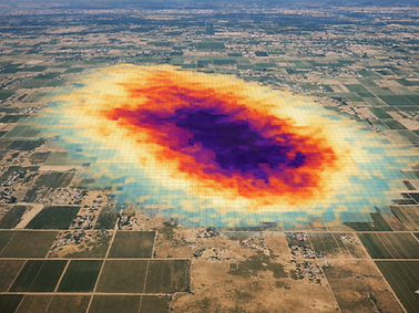
Delivered the first integrated, high‑resolution picture of how much groundwater California’s Central Valley lost during the 20202021 drought, and where that loss is driving land subsidence.
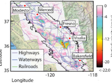
Developed a satellite-informed volumetric strain model of the San Joaquin Valley, an actively subsiding agricultural basin, and used this to pinpoint where groundwater‑driven land motion is most likely to generate hazardous surface fissures and stress critical infrastructure in California’s San Joaquin Valley.

Developed a high-resolution satellite intelligence framework to map vertical land motion (VLM) along the U.S. Atlantic coastline and evaluate how ground deformation is intensifying relative sea-level rise exposure. The assessment shows that widespread subsidence intersects directly with populated coastal corridors, wetlands, and developed land, revealing a critical but underrepresented driver of flood risk and ecosystem vulnerability.
Created high-resolution satellite radar observations to assess how differential subsidence contributes to structural damage and building collapse risk across Lagos, Nigeria (West Africa). The assessment revealed widespread subsidence across much of the city, with spatially uneven settlement producing angular distortions capable of compromising building foundations. The study provides the first structural vulnerability map for Lagos, linking satellite-measured ground deformation to zones of elevated building failure risk.


Developed a global satellite geodetic intelligence framework to quantify surface elevation change across the world’s major river deltas and assess how elevation loss intensifies relative sea-level rise (RSLR). The analysis reveals widespread and spatially variable land sinking in densely populated deltas, demonstrating that ground deformation substantially increases flood exposure, ecosystem loss, and infrastructure vulnerability beyond ocean-driven sea-level change alone.